Deep in the heart of Vietnam's Phong Nha-Ke Bang National Park lies a geological wonder that redefines our understanding of caves. Hang Son Doong, discovered in 1991 but only properly explored in 2009, has captured the imagination of adventurers and scientists alike. Recent expeditions focusing on GPS mapping have revealed astonishing new details about what is now confirmed as the world's largest cave passage.
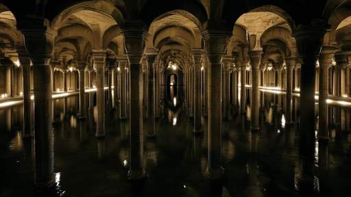
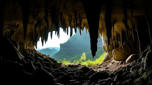
The sheer scale of Hang Son Doong (Mountain River Cave) defies conventional caving experience. Entire New York City blocks could fit within its cavernous passages, with some chambers stretching over 5 kilometers long, 200 meters high, and 150 meters wide. These dimensions create their own weather systems - clouds form near the ceiling, and morning mists swirl through sections dubbed "Garden of Edam" where jungle vegetation thrives under skylight openings.
Mapping the Unmappable
For years after its discovery, the full extent of Son Doong remained unknown. Traditional surveying methods proved inadequate for capturing the cave's sprawling dimensions. This changed when a joint British-Vietnamese expedition team pioneered the use of advanced LIDAR (Light Detection and Ranging) technology combined with high-precision GPS units specially adapted for underground use.
The mapping process presented extraordinary challenges. Unlike surface GPS which relies on satellite signals, the team had to establish a network of control points through the cave using laser distance meters and inclinometers. Each survey station required hours of careful measurement, with teams spending weeks at a time underground to complete sections.
What the mapping revealed was staggering - the main cave passage extends for approximately 9 kilometers, with a total volume estimated at 38.5 million cubic meters. To put this in perspective, Son Doong's largest chamber could contain a 40-story skyscraper. The GPS data also confirmed the cave's connection to the nearby Hang Thung system, suggesting an even larger network may exist.
Underground Ecosystems
The mapping expedition documented more than just geological features. Son Doong hosts unique biomes that have evolved in complete isolation. Explorers discovered pristine forests growing beneath collapsed dolines (skylights), where sunlight filters down to nourish fig trees and rare orchids. The cave's river system contains fish and crustaceans unknown to science, perfectly adapted to the perpetual darkness.
Perhaps most remarkably, the GPS data helped identify previously unknown passages leading to what researchers call "the Great Wall of Vietnam" - a 90-meter high calcite barrier that took weeks to climb and map. Beyond it lies the Pearl Passage, where cave pearls the size of baseballs form in shallow pools.
Technical Breakthroughs
Mapping Son Doong required innovations in underground navigation. Traditional compasses behave erratically due to iron deposits, while radio signals can't penetrate the thick limestone. The solution came from combining inertial navigation systems with ground-penetrating radar, allowing the team to create the first complete 3D model of the cave.
Each expedition member carried customized gear - from rebreathers for traversing flooded sections to modified climbing equipment for the cave's immense stalagmites. The mapping data proved so precise it revealed seasonal changes in the cave's dimensions, with passages expanding and contracting slightly between wet and dry seasons.
The human element remained crucial despite the advanced technology. Local guides from the Ban Doong minority, whose ancestors likely knew of the cave for generations, provided invaluable knowledge about seasonal water flows and hidden entrances. Their oral history helped researchers understand how the cave interacts with the broader karst landscape.
Conservation Challenges
The detailed mapping has raised urgent questions about protecting Son Doong. As word of the cave's wonders spread, uncontrolled tourism threatened to damage fragile formations. The GPS data now helps authorities monitor human impact and establish sustainable visitation limits.
Researchers used the 3D models to identify critical conservation zones, including ancient fossil beds and delicate helictite formations. The mapping also revealed how surface deforestation affects the cave's hydrology, with sediment plumes from distant logging operations appearing in underwater scans.
Scientific Revelations
Beyond its record-breaking size, Son Doong serves as a living laboratory. Stalagmite samples contain climate records spanning hundreds of thousands of years, while unusual bacteria found in isolated pools may hold medical potential. The GPS mapping allowed scientists to precisely locate these features for ongoing study.
The cave's formation story emerged from the survey data. Son Doong appears to have formed along a rare straight fault line, with its massive size resulting from a perfect storm of geological factors - thick limestone beds, consistent water flow, and a protective cap of harder rock preventing total collapse.
Future expeditions will build on this foundational mapping work. Researchers plan to return with improved sensors to study microclimate variations and search for connections to other cave systems. Each visit yields new discoveries - during the last expedition, divers found a submerged passage that may lead to even larger chambers.
For now, Hang Son Doong stands as a testament to Earth's hidden wonders. The successful GPS mapping represents a milestone in speleology, proving that even in our digitally mapped world, profound mysteries still await beneath the surface. As one team member remarked, "We came to measure a cave, and ended up documenting a lost world."

By /Jun 5, 2025

By /Jun 5, 2025

By /Jun 5, 2025

By /Jun 5, 2025

By /Jun 5, 2025
By /Jun 5, 2025

By /Jun 5, 2025

By /Jun 5, 2025

By /Jun 5, 2025

By /Jun 5, 2025

By /Jun 5, 2025

By /Jun 5, 2025

By /Jun 5, 2025

By /Jun 5, 2025
By /Jun 5, 2025
By /Jun 5, 2025
By /Jun 5, 2025
By /Jun 5, 2025
By /Jun 5, 2025

By /Jun 5, 2025